 ar
ar bg
bg hr
hr cs
cs da
da nl
nl fi
fi fr
fr de
de el
el hi
hi it
it ko
ko no
no pl
pl pt
pt ro
ro ru
ru es
es sv
sv tl
tl iw
iw id
id lv
lv lt
lt sr
sr sk
sk sl
sl uk
uk vi
vi et
et hu
hu th
th tr
tr fa
fa ms
ms hy
hy ka
ka ur
ur bn
bn mn
mn ta
ta kk
kk uz
uz ku
ku
water level gauge
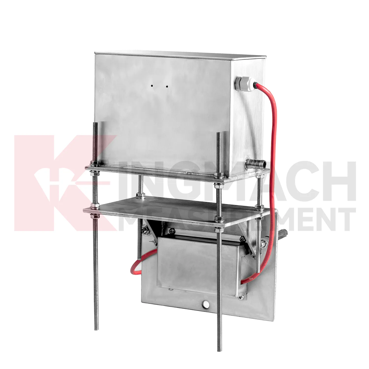
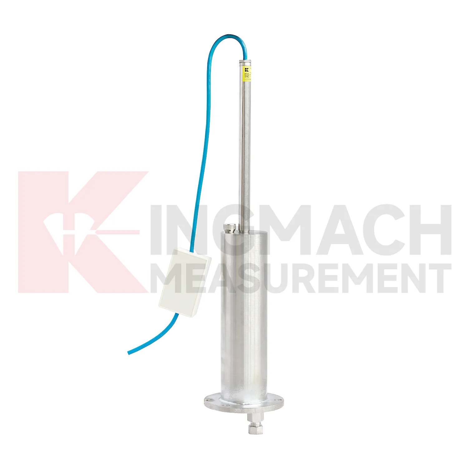
Kingmach water level gauge include the JMDL-47XXAT smart single-point settlement gauge for buried positions where a defined vertical movement must be followed through construction. It is used for subgrade settlement, embankment heave, base uplift in deep foundation pits, tunnel bottom uplift, dyke compression deformation, and pile foundation settlement. Published range options are 100 mm, 200 mm, 300 mm, and 400 mm. Resolution is 0.01 mm on 100 mm and 200 mm models, and 0.1 mm on 300 mm and 400 mm models. Gauge lengths cover 760 mm, 1240 mm, 1720 mm, and 2210 mm. The assembly includes a settlement plate, electrical displacement sensor, measuring rod with metal flexible conduit, anchor head, extension rod, and bottom anchor head. Its side-exit cable design helps reduce interference during pavement compaction. The product is strongest when the installation depth, plate location, cable route, fill layer, and first stable reading are documented before the buried parts disappear under later work.
Application of water level gauge
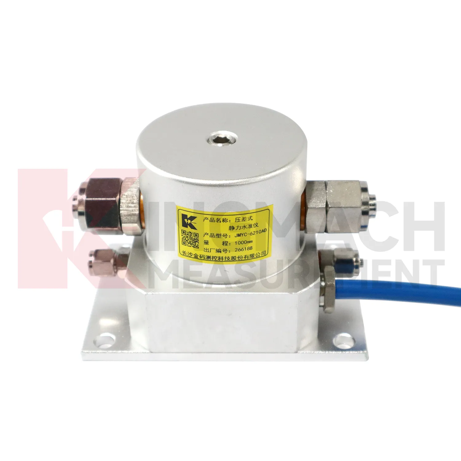
Reclamation and soft ground treatment need water level gauge with enough range to follow large settlement while construction is still changing the load on the ground. In these projects, readings are usually reviewed beside fill height, surcharge placement, drainage progress, vacuum or preload timing, groundwater records, and cross-section drawings. Kingmach JMYC-62XXAD is well matched to this setting because it is a wide-range differential pressure hydrostatic level sensor with 500 mm to 4000 mm range options, 0.1 mm resolution, 0.2%FS accuracy, and RS485 communication. Instead of treating each point as a separate number, engineers can use a reference-point system to see how a whole section is deforming. One area may settle quickly after fill placement, while another reacts more slowly because drainage or soil thickness differs. That profile supports decisions about waiting periods, additional observation, or construction sequencing. The instrument layout should stay clear of heavy vehicle routes, protect cables near temporary roads, and preserve reference stability through the full treatment period.
The future of water level gauge
Remote infrastructure will shape the future of water level gauge. Many settlement points sit along long railways, expressways, dams, embankments, slopes, and tunnel portals where routine manual reading is expensive and sometimes unsafe. Low-power acquisition, wireless gateways, solar power, and clear cabinet layouts can reduce unnecessary visits while keeping settlement trends visible. Kingmach hydrostatic sensors and settlement gauges that support remote data collection can fit this direction, especially when RS485 channels, power supply, and reference points are documented well. Remote monitoring should still include scheduled field checks, because tubes, probes, cables, and reference points can be affected by weather and construction. The best future setup will combine fewer emergency trips with better evidence for deciding when a site visit is truly needed. The practical goal is to keep settlement data understandable after the original installation crew has left, so owners can compare old and new readings without reconstructing the field history from memory. The same record should remain readable for designers, contractors, owners, and maintenance teams, because settlement monitoring often continues long after the first construction report is finished.
Care & Maintenance of water level gauge
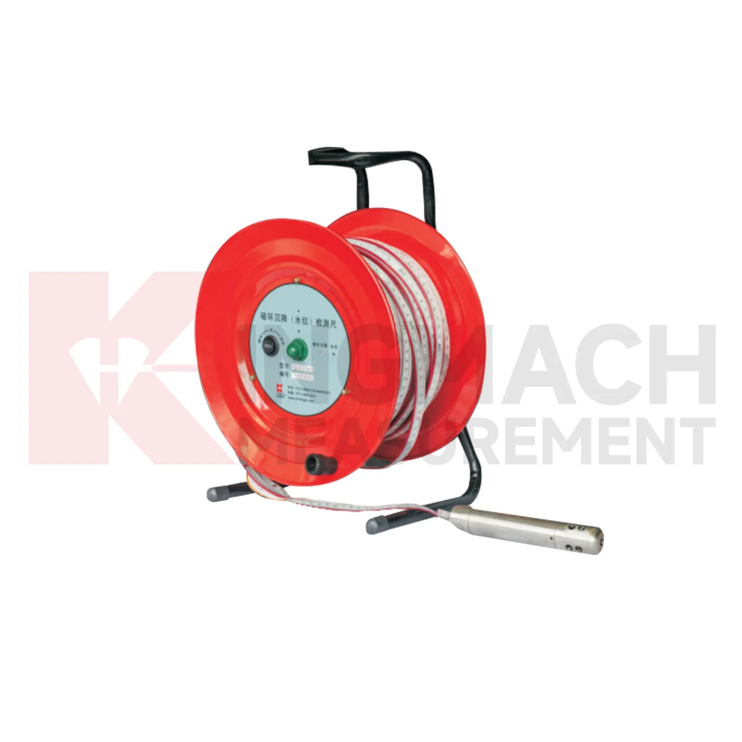
Magnetic ring water level gauge need consistent field habits. For JMCJ-1003/1005, record borehole number, ring depth, water level depth, tape mark, operator, date, battery status, and previous reading each time. The magnetic ring function relies on electromagnetic induction and audible or visual indication, while water level detection responds when the probe contacts water. Different operators should use the same borehole orifice reference mark and the same tape handling method. After field work, clean the probe, dry the reel, inspect the tape cable, check the battery, and note any weak alarm or rough movement in the borehole. Layered settlement data depends on repeated depth reading discipline. A small careless change in reference mark can look like soil compression, so field notes should be plain, dated, and easy to audit.
Kingmach water level gauge
For construction teams, water level gauge help turn ground behavior into decisions that can be made while work is still active. Embankment heave, pile foundation settlement, tunnel bottom uplift, dyke compression, and soft foundation consolidation may all develop during staged loading. Kingmach JMDL-47XXAT is built for embedded settlement and uplift work, with 100 mm, 200 mm, 300 mm, and 400 mm ranges. Its side-exit cable routing helps avoid interference with pavement compaction, which is a small detail with large field value. A settlement point should be checked after each fill layer, excavation step, loading stage, or traffic opening. When readings are paired with construction logs, teams can see whether movement is slowing as expected or continuing into a range that needs attention. The same record should stay readable during handover, because settlement monitoring often continues after the contractor, equipment, and temporary site marks have changed. The same record should stay readable during handover, because settlement monitoring often continues after the contractor, equipment, and temporary site marks have changed.
FAQ
Q: What is JMCJ-1003/1005 used for?
A: It is used to measure layered underground settlement and groundwater level in foundations, subgrades, foundation pits, embankments, and underground structures.
Q: How does magnetic ring settlement reading work?
A: Magnetic rings are placed underground; when the probe senses a ring, audible and visual alerts help the operator read depth from the steel tape at the borehole.
Q: How is water level detected?
A: The water level component works by water conductivity and alerts when the probe contacts water.
Q: What accuracy is listed?
A: The listed measurement accuracy is plus or minus 1 mm.
Q: What field records are needed?
A: Keep borehole number, magnetic ring depth, previous reading, current reading, groundwater level, and operator notes together.
Reviews
Joshua Clark
We ordered a full monitoring solution including sensors and data loggers. Everything works seamlessly together. Great supplier!
Matthew Garcia
Instrumentation cables are durable and perform well even in harsh environments. Will definitely order again.
Latest Inquiries
To protect the privacy of our buyers, only public service email domains like Gmail, Yahoo, and MSN will be displayed. Additionally, only a limited portion of the inquiry content will be shown.
Olivia***@gmail.comUnited States
Hello, we are currently sourcing high-precision strain gauges and load cells for a bridge monitoring...
Emma***@gmail.comCanada
Dear Sir/Madam, we are interested in displacement transducers and settlement sensors for a geotechni...
Related product categories
- deep settlement gauge
- settlement gauge price
- settlement gauges
- Smart Single-Point Settlement Gauge
- hydrostatic level sensor
- hydrostatic level sensor price
- hydrostatic liquid level sensor
- hydrostatic pressure level sensor
- hydrostatic pressure sensor level measurement
- hydrostatic level sensor principle
- hydrostatic level sensors
- hydrostatic pressure level sensors